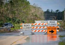

SoHo turned into a street-level flood zone Saturday as heavy rain pushed water deep enough to cover intersections and disrupt travel across New York City.
Quick Take
- Floodwater covered West Broadway and Grand Street in SoHo, according to video reported by The New York Post.
- The National Weather Service said 2 to 4 inches of rain fell, with rates up to 1 inch per hour.
- Flash flood alerts reached all five boroughs and triggered airport ground stops and highway closures.
- City and weather officials said the heaviest rain hit lower Manhattan and parts of western Brooklyn and Queens.
SoHo Streets Submerged in Minutes
Video published by The New York Post showed water covering the intersection of West Broadway and Grand Street in SoHo. Witnesses said the flooding began around 12:15 p.m. Saturday and had fully receded by 2:30 p.m. The images fit a familiar New York pattern. A short burst of intense rain can overwhelm busy streets, especially in dense neighborhoods with poor drainage and heavy traffic.
The National Weather Service said localized rainfall totals could reach 2 to 4 inches, with peak rates near 1.5 to 2 inches per hour. The Independent reported that by Saturday afternoon, 2 to 4 inches had already fallen in parts of the city, with downpours reaching up to 1 inch per hour. That kind of rain can flood streets fast, even when the storm does not last long. New York City Emergency Management had warned that isolated spots could receive 2 to 4 inches.
Travel Disrupted Across the City
Flash flood alerts went out across all five boroughs as the rain intensified. The same storm also triggered ground stops at New York’s busiest airports and closures on major highways, according to reports. The Independent said subway lines were disrupted and hundreds of flights were grounded ahead of the World Cup final. That means the storm did not stay confined to SoHo. It hit the city’s transportation network from the streets up.
Officials said the heaviest rain fell in lower Manhattan and parts of western Brooklyn and Queens. That matters because these areas already face a high flood risk when storms stall over the city. The National Weather Service also warned that urban, low-lying, and poor-drainage areas could see isolated to scattered flash flooding. In a city built on tight blocks and old infrastructure, a few inches of rain can quickly become a public safety problem.
What the Storm Says About City Readiness
The SoHo flooding shows how fast city streets can fail when heavy rain arrives all at once. It also shows why officials move quickly when flood alerts are issued. New York City Emergency Management told residents to be ready to move to higher ground and avoid floodwater. That advice is basic, but it reflects a hard truth. In a storm like this, delay can leave drivers, walkers, and subway riders trapped.
Strong storms on Saturday flooded streets across SoHo in Manhattan, leaving parts of the neighborhood covered in rising water.#SoHo #Manhattan #NYC #Flooding #Storms #Weather #Breaking https://t.co/dfzw0S3hqW pic.twitter.com/JuFV3yJLaG
— The Globe & News (@TheGlobeNewt) July 19, 2026
There is one important limit in the public reporting. The available stories describe SoHo flooding clearly, but they do not provide an official rainfall reading for SoHo itself. The reports also give witness timing for when the water rose and fell, but not a formal incident log for that block. Even so, the core picture is plain: a fast-moving summer storm turned parts of lower Manhattan into standing water and snarled movement across the city.
Sources:
nypost.com, weather.gov, independent.co.uk, norwoodnews.org